


 (Office Hours:AM9:00 ~ PM6:00)


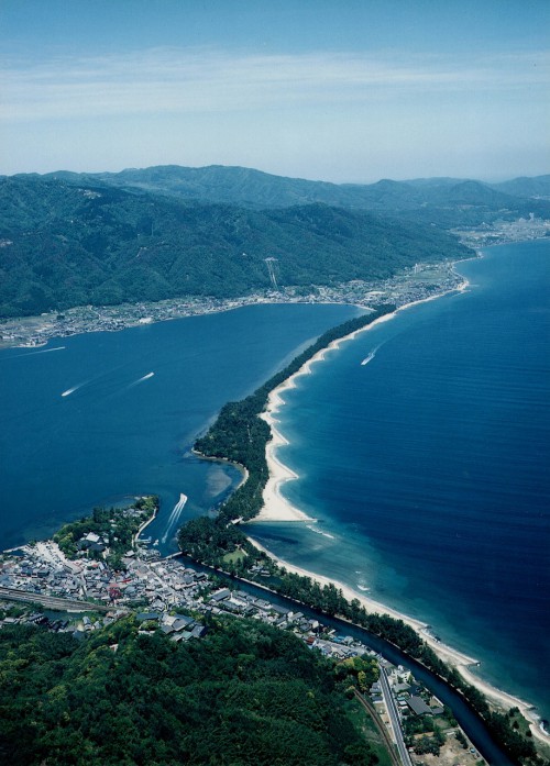
Amanohashidate
Amanohashidate is a natural land bridge in the northern part of Kyoto Prefecture. Along with Matsushima in Miyagi Pref. and Miyajima in Hiroshima Pref. Amanohashidate has for centuries been named one of Japan’s most famous scenic landscapes. This natural land bridge is a sandbar that spans 3.6 km across Miyazu Bay, and ranges from 20m to 170m in width. This sandbar is home to around 8000 Japanese pine trees – a rare sight to see so many of these beautiful trees in one place. The name ‘Amanohashidate’ means ‘bridge to the heavens’ and was named for its shape when seen from the lookout points at either end of Amanohashidate – the land bridge looks as if it leads up into the sky.
Amanohashidate has been moulded into the shape it is today through mysterious natural forces, over thousands of years.
It can be viewed from the lookout points at either end and visitors can also walk or cycle across it, take the ferry alongside it, or swim at the beach on it’s northern side. (Walking across takes about 50 mins one way; while cycle takes around 20 mins).
Amanohashidate has entered many of Japan’s “Top 100” lists including: Japan’s Top 100 pine trees; water spots; streets; sand blue pine trees; sea shores; beautiful Japanese historic places; Japanese historic parks; and geological features.
| Spot Name | Amanohashidate |
| Address | Monjuamanohashidatekouen, Miyazu, Kyoto [ Map ] |
| Reference |
Amanohashidate Station Tourist Information Center TEL:0772-22-8030 |
test
| Location Map | (*)Google Maps will open in a separate window.
|
| Access | About 5 minute walk from the North Kinki Tango railway Amanohashidate Station . About 10 minutes by car from Miyazu Amanohashidate IC. |
| Parking | Available (pay) |
| Nearby Spots | |
| Category |